Bike Adventure


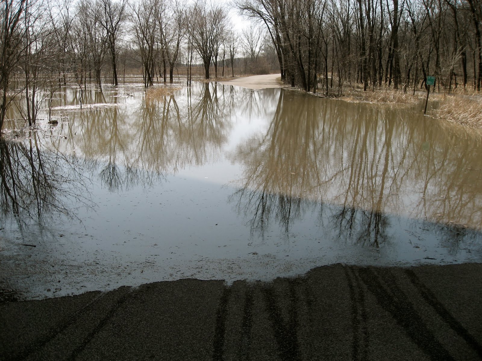
The man on the hill had all the answers. Not that we had even asked the questions, but upon stopping to exchange pleasantries with this middle-aged visitor on his cruiser bike at the back entrance to Crosby Farm Park, his little dog in tow, he proceeded to give us the full rundown. In truth I wasn't tracking all the details as he carefully laid them out, but I got the gist: The first part of the path had been cleared of cattails, grasses, and other debris; at some point there were "lakes" to circumnavigate (he didn't mean the actual lakes in the park, but what I would call large puddles covering the trail); there were downed trees to go over or under; there were extremely muddy patches and one slice of trail, like a gully, that had been completely filled by deep sand deposited by the surging river. He spoke of a "secret trail" that when described soon revealed itself as one quite well known to us (part of our typical cross country skiing route). He didn't know that we'd already done an exhilarating slice of off-road biking, having turned back at one of his lakes when coming upon it from the opposite direction, and biking, as best we could, the dirt path along the bluff on other side of the real lakes. And despite all the details he had disclosed, which might have acted as spoilers, the plot of the movie revealed before seeing it, none of that made a dent in what would continue to be a true bike adventure.


It was like a haunted landscape. The remains of trees, large and small, were strewn across the path (we could bike over or through the small stuff, but when I observed a mountain biker attempt to roll over one of the medium sized branches blocking the path, he nearly capsized. Yes, there were gullies, trenches full of sand much too deep to be bike-able. The main patch was indeed much too muddy in spots, and those lakes were formidable, so we found ourselves on the "secret" trail; it was mostly dry and quite narrow.


What he hadn't revealed was that erosion had caused the riverbank to cave in along stretches of this trail. An adventurous biker might have hugged the inner edge of the trail to avoid the six-foot drop to the actual riverbank, but I dismounted and walked through a couple of tight stretches. It's hard to describe the other-worldly atmosphere in those dark woods. The
bottomland was soaked, with sporadic lakes and puddles, downed trees and debris both natural and un-.


On the bluff side, marsh marigolds, skunk cabbage, bloodroot, and Dutchman's breeches were emerging. Chickadees and Eastern Phoebes appeared here and there, looking magical, and even the first Great Blue Heron of the year was incredibly striking. Maybe it's because these woods are so familiar to me from years of walking, skiing, and biking through them. For the first time they felt unfamiliar; even the sounds and smells were foreign.


Then there's the fact that the barriers – the sand, mud, and lakes – were still keeping most of the riffraff out. Sure, we ran across the odd mountain biker or too-happy family, but for long stretches we felt alone in these woods, which, considering that they sit in the heart of a major metropolitan area, was a more than pleasant surprise.


It was more than just fun getting back into these bottomlands (finally) after the spring floods – it was a true adventure. We were even able to complete the circuit, biking back long the riverbank through Hidden Falls Park. Yes, though not perfectly navigable, all of the old pathways in the river flood-plain are open again. Well, open to bikes, anyway.


Zeal


An unseasonably warm and sunny Saturday afternoon – what better time to get out for a spin on the bike? Actually, as I was about to find out, there are plenty of better times. I zipped right out into a headwind, with a fairly definitive route in mind, thinking I'd make it a workout ride. What I hadn't accounted for was the weakness of my winterrubberwhite legs and the crowded trail conditions. Yes, everybody and his/her mother was out walking on the trails. Some walked on the bike trail, not knowing or not caring about the parallel designated walking trail but a few yards away. Lots and lots of walkers. Some had sticks, some didn't. Some were oblivious, others less so. Some seemed terrified upon discovering that a man riding a bike was calling out to them, attempting to pass them on the left. It was as if they'd never seen a man on a bike before, as if a chimpanzee mounted on a camel were galloping up on their rear– such was the registration of shock and misapprehension on their faces. Others couldn't care less, and made little attempt at accommodation. Surprisingly, the ones with sticks were relatively sensitive regarding these matters, even apologetic.

I changed routes almost immediately, deciding on a whim to check out one of my old favorites, the bottomland area just south of the Franklin bridge on the east bank of the Mississippi. The flood waters had well receded, leaving some patches of brackish backwater that only a single brave mallard dared to ply.


The trail was dusty, it was windy, and I was weak. I kept going though, up past the U of M ...


... down the dirt pathway along the rail corridor, and up to the Stone Arch Bridge (predictably crowded) and stopped to see if my old friends, the annual cormorants, were in their tree below St. Anthony Falls yet. They were not.


By this time I was already acknowledging my own lack of zeal. I'd planned to go up around the Boom Island loop, maybe even reconstitute another old favorite (Nicollet Mall - Loring Greenway - Loring Park - Cedar Lake - Midtown Greenway). But somewhere downtown along the west bank of the river I lost interest and motivation in any structured route and found myself just poking around, looking at tourists and people with dogs and funny haircuts.


Truth to tell, I was more interested in taking pictures. The zeal for photography was still there, and I mean in a back-to-the-basics way, like when I very first started back in college. I didn't care about representation or information; my interests were pure: form, line, texture, color, and the like.


It was only after having given up on the ride and heading back home that the magic of biking surprisingly took hold. I suppose that's because I chose to head back south on the Light Rail Trail. Because is isn't "scenic" (unless, like me, you find semi-industrial urban rail corridors seductive) it was pleasantly free of other folks. There were a few bikers, and almost no walkers. I hit my stride, found the magic and joy of biking after all, and even put some shape into those rubberwhite legs ... I got a workout in and had a great time after all.

Spring Floods

Last year I had so much fun riding through puddles and rivers that this spring I made sure to get out on the bike when the water was still high. The difference was that this year the water was much higher. The first time I tried to cruise through a puddle down in Crosby Farm Park, I quickly found that I'd made a serious misjudgment; before I knew it I was up to my knees in muddy water. I had to abandon the pedals, get off the bike, and exit, stage right. I slogged through some soupy bottomland woods until I reached the interior path and could ride again.


For several weeks I continued to attempt loop rides around the basic Ft. Snelling-Mendota-Lillydale-Crosby-Hidden Falls configuration. Fort Snelling State Park was soon underwater, with access to Pike Island only available to the brave or foolhardy. Lilydale Road was subsumed with water starting at the railroad viaduct. Hidden Falls was out of the question, with water over the trail and park, all the way back to the bluff in spots. As the waters rose (on the Mississippi, but even more so on the Minnesota River) biking in any of my usual bottomland spots was ruled out more definitively than ever. The whole of Crosby Farm park was underwater, as was the entire riverbank stretch of Lilydale Road. Even the crossing from the trail, coming down off of the bluff and trying to access the trail on the other side of the road that spins you up to the I-35E bridge trail was inundated; USGS folks were using this area as a boat put-in.


It made for fun adventures, even though so many areas were off limits. It forced me onto the high paths where there were great vantage points to survey the impact of the river surges: up at the Fort Snelling overlook;, from the bike lane of the Mendota Bridge; at one point from atop the railroad viaduct and elevated rail tracks at Lilydale; from the I-35E bridge; from Shepard Road above Crosby Farm, and from a designated overlook above Pike Island in Saint Paul, where Shepard Road meets highway 5.


From these high vantage points I accumulated a nearly 360ยบ view of the river valley. I witnessed, over time, the trails, roads, and parking areas of Fort Snelling State Park overtaken by the Minnesota River. I saw Picnic Island, where we had indeed stopped to picnic during our paddling adventure last fall, disappear. Pike Island, longer and larger, was like a sinking ship; I watched the front tip down and go under. Hidden Falls park was beyond hidden -- it seemed to be non-existent. The river access road flanking the I-35E bridge had become a river in its own right. I never thought I'd see the river take the whole of Crosby Farm, but it did; the two lakes there became part of the river as the waters pushed all the way back to the bluff.


Eventually the waters receded and I was able to resume some of my regular rounds. I was lucky enough to ride the full Lilydale route on the first day that it was opened to traffic; there were a couple of muddy spots and some puddles but nothing to trouble a reasonably intrepid biker. It was exhilarating to bike the section along the riverbank, as the water was still right up to the edge of the road; it was almost like biking along the surface of the river itself. Also captivating was the discovery of new wetlands and wet micro-environments along the way. I found it quite satisfying to at last complete that longer Lilydale loop, although Crosby was still out of the equation on the return. The big surprise there was the loud chorus of Hyla Crucifer (Spring Peepers) ringing out from the Mississippi bottomlands.


Catching Up

04/12/2010

in the neighborhood


along the mighty miss.

Well, it's been about a year now since Bikelogue sank ... for predictable reasons: travel, work, wanting to just ride as opposed to document the ride, and most of all, the time-consuming ritual of writing up an entry, working up a set of photos, and finally posting to a blog that no one reads. Well, almost no one. With encouragement from a single reader, this bikester/blogster is ready to make another go of it.


Thinking back on last year's rides, without thinking too hard, the best memories are of really breaking in the "Wildlife Area" ride: that loop on the gravel through the Minnesota Valley National Wildlife Refuge, over the Cedar bridge, and then back on the dirt/mud "mountain bike" trail along the banks of the Minnesota River back into Mendota.


Sometimes I would take the full ride from my house, through Minnehaha Park; down below Fort Snelling and through the State Park; then up and across highway on Post Road between the airport terminals; past the Fort Snelling national military cemetery and alongside the light rail tracks down into Bloomington and finally over to the wildlife area. If I wanted a shorter ride or simply wanted to spare myself the sections of the ride that necessitated sharing the road with crazed suburban commuter cars, I would hop on the light rail with my bike and ride to Bloomington Central station, hop out there and ride the short jaunt over to the wildlife area.
Either way, it was always a fun ride (this forty-something man saw his first wigeon and first baby snapping turtles on this route), and sometimes I was able to take a fun side trip down Old Cedar Road, complete with side-streams and downed tree obstacles and adjacent wetlands, up to the old (closed) bridge and back.

Old Cedar Road

Old Cedar Bridge

Early in the year both sides of the loop could be soft and soggy, and there was lots of fresh gravel on the wildlife road, so it was a tougher ride. Later in the summer the dirt was dry and hard, and the gravel was well packed, so it became a super workout ride if one wanted; I could really fly along on my cross bike, just scream along on the sparsely populated trail.


Cedar Ave Bridge -- Bikers' Accommodation

Heading back downriver on the Mendota side

Another thing that came out of these rides was the strange idea I got of paddling a stretch of the river. And it came to fruition: come October, a group of six of us put in under the Cedar bridge, fresh snow still on the boat ramp and dusting the logs along the river bank, and paddled down to Harriet Island in Saint Paul, guided for at least part of the way by a wounded Pelican.

April 22, 2009

A Wednesday evening and quite bike-able – warm and lovely in the TC. At this point I figure I should start to stretch out my rides a bit; there's no excuse (weather, conditioning, daylight) to not go for a longer ride. I decide to do my old downtown loop with and extra loop (Basset Creek) lumped on top. The last time I did the downtown loop was Easter and the last time I did Basset Creek was years ago (in fact I think I've only biked that trail two, or maybe three, times ever).

Yes. a lovely day for cruising, and I keep the camera in the pocket as I have a lot of ground to cover before dark. But when I get to Loring Park it is so stunningly beautiful and pleasant, such an unbelievable little gem in the heart of the urban space, that I can't resist stopping on a little bridge there and looking at the ponds, the sky, the people, and the birds. Red-winged Blackbirds are everywhere, some fighting over territory. Wood ducks calmly ply the reflective waters under puffy clouds.


Back on the trail, I get to my usual left turn under I-94 and jog just slightly to the right this time, then cycle up, climbing the spiral walkway to cross over the old rail corridor and area the city uses for materials, scrap, and whatnot. It's been a long time since I've been over this way, but I find my way onto the old patchwork of trail sections, streets, and bridge crossing very easily and naturally, as surely as I found my way from the Central Station to the Vondel Park youth hostel in Amsterdam after having only been there once two years earlier.

Here it's shaping up to be a wonderful evening – folks are playing soccer in Bryn Mawr Park, and further up there are several groups of adults playing a game we used to call kick-soccer (also known as kickball to many) in Bassett's Creek Park, not a few of them lolling about or sitting on the trail as though it were some kind of sideline bench. I just carefully run that gauntlet as they stare, as though I were the oddball. Here I pull up to Glenwood Ave by the old bottling plant.

And I know I should keep moving for time's sake, but I can't help a quick search for the remains of the secret spring that and Eastern European follow told me about back on one of my early rides. It use d to be mobbed on Saturday mornings by people coming to collect the supposedly medicinal waters until it was closed off by the authorities. All I know is that he said it was in this general area and off of Glenwood Ave, so I poke around a little off the road in likely spots.

Could this be it?


Or this?


I'll never know. Later I would try some Internet research and only find the notions that there were indeed two natural springs near here (Glenwood and Great Medicine, the latter in Theodore Wirth Park), and apparently MNDOT drained and closed these as part of the I-394 building project. I'm utterly curious about this whole matter, but can't find anything more about it ... yet.

For now I'm on a beautiful ride, and I know I should not have taken time out to look for the secret spring and take pictures. I consider turning back for a shorter loop home as the sun is rapidly sinking in the sky. I figure if I have an hour of daylight left I'll be fine though and pull out my phone to check the time. Oops – by my rough calculations I've only got about 35 minutes. Still I can't resist following the rest of the creek trail as the next section is the one I'd looked forward to, so over the bridge I go and onto the rough, broken, narrow, muddy trail that leads through secret woods and next to intriguing backwaters and ponds. I've got he right bike but the wrong tires, again, for this rough terrain, but I do just fine, and it's a hell of a lot of fun to pick my way through on the best level spots.

This fun stretch of trail is shorter than I remembered, though, and before I know it I'm dumped out into Theodore Wirth well north of Highway 55, with the sun going down and actually quite close to a "bad" part of town (North Minneapolis), although you'd never guess that in this quiet parkland. I start heading down the road, south, and actually get a little turned around at the intersection of Wirth Parkway and Plymouth Ave North. Someone has pulled a trick and revolved the signpost so that the actual streets are represented opposite of reality. I'm a little disoriented, still, but believe it or not when I see an old model car with exhaust pouring out of its tailpipe and the stereo blaring go tearing up what is labeled as Wirth Parkway, I just know that is the wrong way. I head south on the real Parkway and before long all is familiar again, with known spots like the quaking bog and Eloise Butler wildflower gardens along the route. I really get pumping here, seeing as it is getting dark and I'd like to at least hit the Greenway before the sun really sets. There are some hills in here too so I start to get a real and genuine workout. I sneak across Highway 55 (something I normally would never do) because of the late hour and clear opportunity to do so. It's shaped up to be an incredible evening, and even though I'm running late, I can't resist stopping to take a look at a and photograph of one of Minneapolis' lesser known lakes (Brownie).


After this point the ride is no longer in question – it's no longer exploration, but a full-on workout. As I skirt around the western edge of Cedar Lake, riding the road in favor of the trail around the other side), I'm lathering up and in full racing mode. I grab the remaining chuck of the Kenilworth Trail and by the time I make the turn onto the Midtown Greenway, I'm embarrassed to admit that I begin to cramp. I get a cramp in my left, then right, calf. Unbelievable – I don't remember this since soccer tournaments a decade or more ago. Well, I did work out hard the day before, and recently upped my running mileage at the gym, so ... maybe ... or could it be that I'm just getting old?

Experience comes with age, though, and I adapt my pressure on the pedals and settle into an easy groove, just spinning to keep the cramps at bay ... no time to stop. And it's as enjoyable as ever, after all, to sail back on the Greenway as the light drains from the sky behind me ... very very slowly. In the end I make it all the way back home before it even get close to real darkness, and I guess I'm about as satisfied and proud as I could reasonably be for a middle-aged exploratory urban biker with a blog that no one reads.